
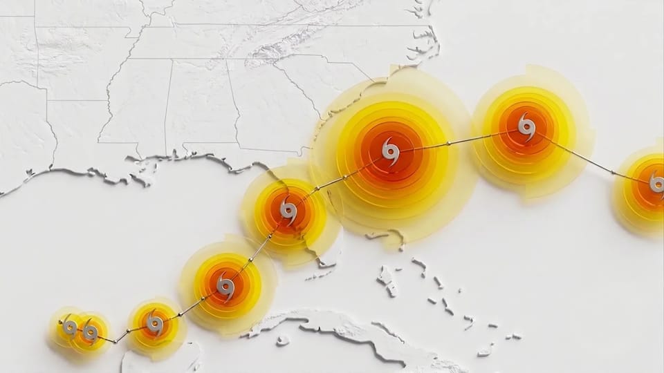
WeatherNext by Google DeepMind: AI Achieves Breakthrough in Tropical Cyclone Forecasting
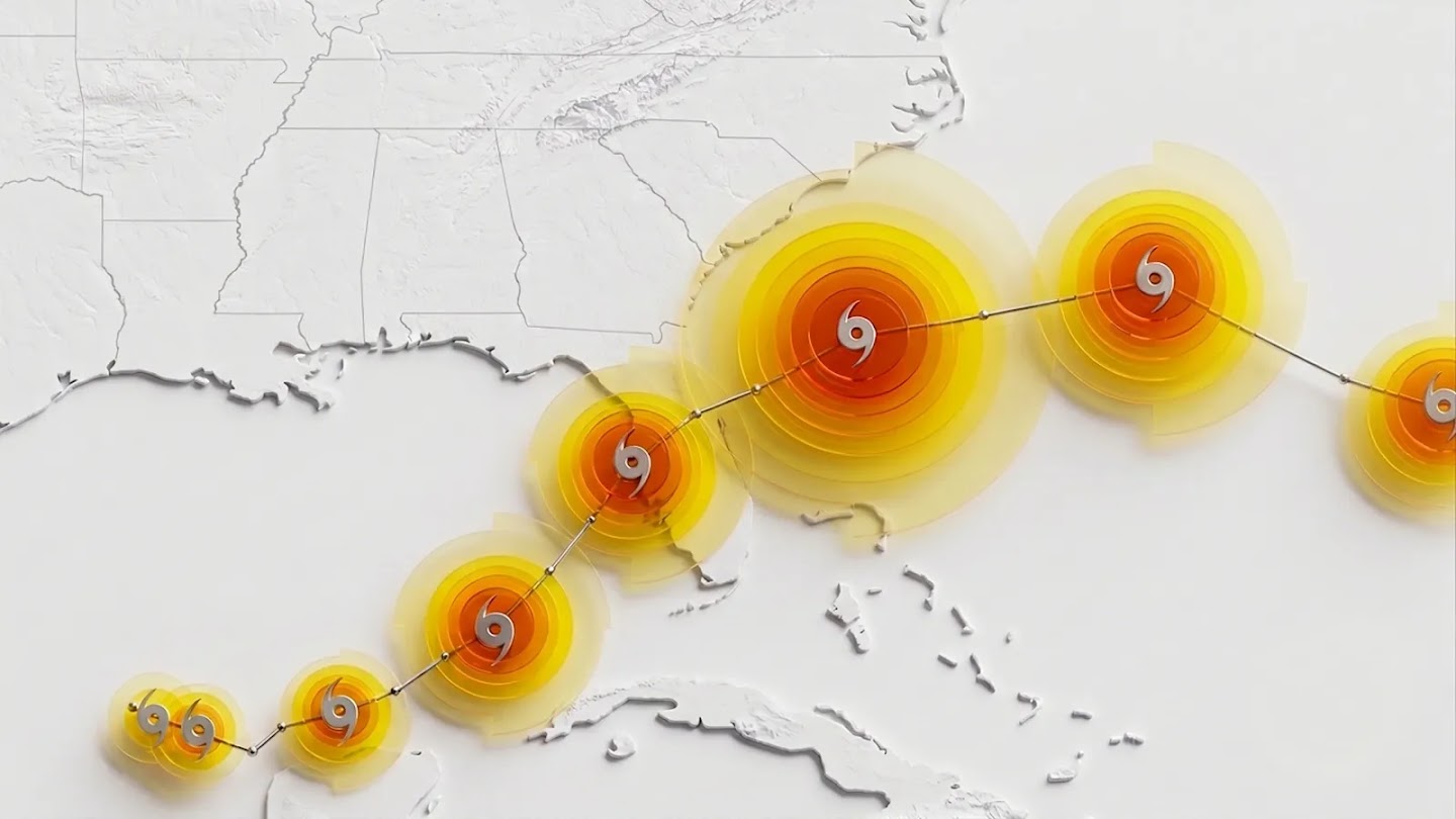
Tropical cyclones have killed more than 700,000 people and caused $1.4 trillion in economic losses globally over the past 50 years. Every additional hour of warning before a storm makes landfall saves lives, protects infrastructure, and gives emergency responders the time they need to prepare. On August 6, 2026, Google DeepMind and Google Research published a paper in Nature describing an AI model called WeatherNext Cyclones that delivers what meteorologists would call roughly a decade's worth of progress in a single release — gaining more than a full 24 hours of useful forecast lead time across cyclone track, intensity, and wind structure predictions.
This is not an incremental improvement. WeatherNext Cyclones can generate a complete 15-day forecast in under one minute on a single TPU, it is open source, and it has already proven itself during a real hurricane season alongside the U.S. National Hurricane Center (NHC). In this article, we unpack what makes this model important, how it works technically, where it still falls short, and why it matters for hundreds of millions of people living in cyclone-vulnerable regions worldwide.
What Is WeatherNext Cyclones?
WeatherNext Cyclones is a machine learning model developed by Google DeepMind and Google Research specifically for tropical cyclone forecasting. Unlike general-purpose weather models that predict broad atmospheric conditions, WeatherNext Cyclones was co-trained to excel at three of the hardest problems in tropical meteorology simultaneously:
- Track forecasting — where the storm will go over the next 15 days.
- Intensity forecasting — how strong the storm will become (wind speed, central pressure).
- Wind structure forecasting — the spatial extent and shape of dangerous winds around the storm.
The model achieves state-of-the-art performance across all three dimensions, which is notable because traditional forecasting has historically required separate models for each. Track forecasting has typically relied on coarse-resolution global models (because cyclones are steered by large-scale atmospheric currents), while intensity forecasting has required high-resolution regional models (because storm strength is driven by fine-scale thermodynamic processes like eyewall convection and ocean heat content). WeatherNext Cyclones bridges this divide within a single neural network.
The model was operationalized during the 2025 Atlantic hurricane season under the internal designation FNV3 (publicly referred to as WeatherNext Cyclones), and it was used by the NHC alongside traditional tools. Three model versions have now been open sourced on GitHub: WeatherNext Cyclones (full), WeatherNext 2, and WeatherNext 2-mini.
What This Means for You: Global Relevance
Tropical cyclones are not a regional problem — they are a global one. WeatherNext Cyclones matters directly for people, businesses, and governments in every cyclone-prone basin on Earth.
Gulf of Mexico and the Caribbean
The Atlantic hurricane season threatens the entire U.S. Gulf Coast, Florida, the Caribbean islands, Mexico, and Central America. The 2025 hurricane season alone demonstrated how rapidly a storm can intensify and how critical advance warnings are. WeatherNext Cyclones was used operationally by the NHC during this season, contributing to historic forecasts. For residents of Miami, New Orleans, Houston, Havana, and San Juan, an extra day of accurate lead time means an extra day to evacuate, board up homes, stage emergency supplies, and protect critical infrastructure.
South Asia
The Bay of Bengal and the Arabian Sea produce some of the deadliest cyclones in recorded history. Bangladesh, India, Pakistan, and Sri Lanka have collectively suffered hundreds of thousands of cyclone-related deaths over the past century. The India Meteorological Department (IMD) and regional warning centers could leverage models like WeatherNext Cyclones to improve evacuation planning for densely populated coastal regions where even small improvements in track accuracy translate into massive reductions in unnecessary evacuations and saved lives.
Middle East: Oman and Yemen
Oman's coast along the Arabian Sea and Yemen's Socotra archipelago are directly in the path of Arabian Sea cyclones. Cyclones like Mekunu (2018) and Shaheen (2021) caused significant damage and loss of life in Oman. The region's arid terrain also means that cyclone-induced flooding can be especially destructive, as the ground absorbs water poorly. Better intensity forecasts — particularly for rapid intensification events — would give Omani and Yemeni authorities more time to protect coastal cities like Salalah and Mukalla.
East Asia
The western Pacific is the most active tropical cyclone basin on Earth, producing storms that affect the Philippines, Taiwan, Japan, China, Vietnam, and South Korea. The Japan Meteorological Agency (JMA), the Philippine Atmospheric, Geophysical and Astronomical Services Administration (PAGASA), and China's Meteorological Administration (CMA) each maintain sophisticated forecasting systems, but the sheer volume of storms in this basin means that any improvement in ensemble-based probability forecasting — particularly for rare rapid intensification events — is enormously valuable.
Insurance, Logistics, and Energy Sectors
Beyond government agencies, the private sector benefits enormously from better cyclone forecasts. Insurance companies use cyclone tracks to price catastrophe bonds and model risk exposure. Shipping companies reroute vessels around storms. Oil and gas operators in the Gulf of Mexico shut down and evacuate offshore platforms when storms approach — a process that costs millions of dollars per day. An extra day of accurate lead time allows all of these industries to make better-informed decisions.
Quick Comparison: WeatherNext vs. Traditional Models vs. Previous AI Models
| Dimension | WeatherNext Cyclones | Traditional Numerical Models (ECMWF-ENS, HWRF, NOAA GFS) | Previous AI Weather Models (GraphCast, GenCast, Pangu, FourCastNet) |
|---|---|---|---|
| Primary strength | Cyclone track + intensity + wind structure in one model | Physics-based, interpretable, globally trusted | General global weather forecasting, not cyclone-specific |
| Forecast speed | 15-day forecast in under 1 minute on a single TPU | Hours on supercomputers with thousands of CPUs/GPUs | Minutes on a single GPU/TPU |
| Ensemble capability | Up to 1,000 ensemble members | ECMWF-ENS: 51 members | GenCast: up to 50 members |
| Resolution | 28 x 28 km (coarser input, but SOTA intensity output) | 9 km or finer (ECMWF HRES); HWRF uses 2 km nested grids | Typically 0.25° (~25 km) |
| Rapid intensification capture | Strong, validated on 2025 Hurricane Melissa | Moderate — physics models struggle with RI prediction | Not specifically designed for this |
| Open source | Yes — code + weights on GitHub | Partially — ECMWF's OpenIFS is limited; IFS itself is proprietary | GraphCast and GenCast are open source; Pangu is open source; FourCastNet is open source |
| Track record | One operational hurricane season with the NHC | Decades of operational use worldwide | Limited operational deployment |
The most important distinction is that WeatherNext Cyclones is the first AI model specifically co-trained on both global weather dynamics and curated cyclone observations. Earlier AI models like GraphCast (which was developed by DeepMind and published as "WeatherNext Graph" in the repository) and GenCast ("WeatherNext Gen") were designed for general weather prediction. They were not optimized for the unique challenges of tropical cyclones — the small spatial scale of eyewalls, the nonlinear dynamics of rapid intensification, and the complex interaction between a storm's inner core and its large-scale environment.
Traditional models remain the gold standard for interpretability and physical consistency. An ECMWF forecaster can explain why a storm is predicted to turn north by pointing to a trough in the mid-latitude westerlies. WeatherNext Cyclones, as a neural network, does not provide the same level of causal explanation — a limitation we discuss later in this article.
Technical Deep-Dive: How WeatherNext Cyclones Works
Architecture: Functional Generative Networks (FGNs)
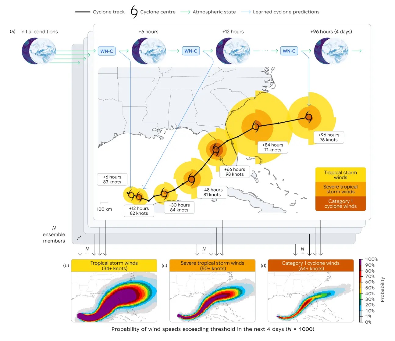
The core of WeatherNext Cyclones is a Functional Generative Network (FGN), an architecture detailed in a companion paper (arXiv: 2506.10772). FGNs are designed to efficiently produce ensembles of different predictions, which captures the inherent uncertainty of weather forecasting. This is a critical design choice: tropical cyclones are chaotic systems, and a single deterministic forecast is rarely sufficient for decision-making. By generating probabilistic ensembles, WeatherNext Cyclones can produce localized probability maps of tropical-storm-force and hurricane-force winds — the exact products that emergency managers need.
This architecture represents a departure from DeepMind's earlier weather models. GraphCast used graph neural networks (GNNs) to represent the Earth's surface as an icosahedron mesh. GenCast used a diffusion-based approach to generate ensemble forecasts. WeatherNext Cyclones uses FGNs, which the team describes as a more efficient method for ensemble generation at the scale needed for operational tropical cyclone forecasting.
Training Data: Two Modalities, End-to-End
WeatherNext Cyclones was co-trained on two distinct data modalities simultaneously:
Modality 1: Global Atmospheric Reanalysis (ERA5)
The model ingested approximately 20 terabytes of global atmospheric data derived from ECMWF's ERA5 reanalysis product. ERA5 is a meteorological reanalysis dataset produced by the European Centre for Medium-Range Weather Forecasts (ECMWF) as part of the Copernicus Climate Change Service. It provides hourly snapshots of the global atmosphere on a 31 km grid from 1940 to the present, integrating observations from radiosondes, weather balloons, aircraft, buoys, satellites, and scatterometers through ECMWF's physical model. ERA5 is widely considered the gold standard for historical atmospheric data and is the training dataset of choice for most modern AI weather models.
Modality 2: IBTrACS — The International Best Track Archive for Climate Stewardship
The model was additionally trained on the IBTrACS database, maintained by NOAA's National Centers for Environmental Information (NCEI). IBTrACS compiles best-track data from all official Regional Specialized Meteorological Centers (RSMCs) and Tropical Cyclone Warning Centers (TCWCs) worldwide into a unified record spanning nearly 5,000 historical tropical cyclones. It includes data from agencies such as the NHC (NOAA), the Joint Typhoon Warning Center (JTWC), JMA (Japan), the UK Met Office, Météo-France, the Bureau of Meteorology (Australia), CMA (China), and IMD (India). IBTrACS provides expert-curated best-track positions, intensities, and wind radii for each storm — the ground truth that WeatherNext Cyclones learns from.
By co-training on both modalities end-to-end, the model learns to correlate large-scale atmospheric patterns (from ERA5) with specific cyclone behavior (from IBTrACS). This dual-modality approach is a key innovation: it allows the model to understand both the steering environment and the storm itself.
Resolution Paradox
One of the most surprising findings is that WeatherNext Cyclones achieves state-of-the-art intensity forecasts despite operating on input data with a spatial resolution of only 28 x 28 km — approximately 100 times coarser than the nested grids used by high-resolution regional models like HWRF (which runs at 2 km resolution near the storm center). The DeepMind team notes that this "has surprised scientists" and remains an open research question. It suggests that the model is learning to extract intensity-relevant information from the large-scale environment that traditional models require explicit fine-scale physics to capture.
A compact variant, WeatherNext 2-mini, operates at an even coarser 111 x 111 km resolution and can run on a single TPU in a free public Google Colab notebook, making the technology accessible to researchers and meteorological agencies worldwide.
Speed and Ensemble Scaling
WeatherNext Cyclones can generate a single 15-day forecast in less than one minute on a single TPU. This is orders of magnitude faster than traditional numerical models, which require hours on supercomputing clusters.
During the 2024 hurricane season, the model produced 50 ensemble members at a time — matching the ensemble size of global physics models. For 2025, the team scaled the ensemble to 1,000 members. This massive ensemble size enables the model to capture rare but consequential scenarios, such as rapid intensification events, that smaller ensembles might miss entirely.
Evaluation
The model was evaluated on historical cyclones from the 2023–2024 seasons. Key benchmark results include:
- 3-day track position error: approximately 100 km (compared to higher errors from ECMWF-ENS)
- 3-day intensity error: approximately 11 kt (compared to HWRF)
- Overall lead time advantage: more than 24 hours across all three dimensions (track, intensity, wind structure)
The practical meaning of these numbers is striking: a 3-day WeatherNext Cyclones forecast is approximately as accurate as a 2-day forecast from previous systems. This translates to an extra day of preparation time for communities in a storm's path.
Hurricane Melissa: A Real-World Validation
During the 2025 Atlantic hurricane season, WeatherNext Cyclones helped the NHC make what it described as a historic forecast for Hurricane Melissa. The model accurately predicted the storm's rapid intensification and its landfall in Jamaica — an unusual and difficult-to-forecast track. This enabled the NHC to issue an advance warning, giving teams on the ground critical time to prepare. The NHC collaboration also involved the Cooperative Institute for Research in the Atmosphere (CIRA) and the UK Met Office, demonstrating the model's integration into international operational forecasting workflows.
Google DeepMind published a dedicated follow-up post about the Melissa case in May 2026, highlighting how the 1,000-member ensemble captured the rapid intensification signal that smaller ensembles had missed.
Honest Limitations: What WeatherNext Cyclones Cannot Do Yet
No model is perfect, and responsible journalism about AI requires acknowledging what WeatherNext Cyclones does not yet accomplish.
1. Interpretability
WeatherNext Cyclones is a neural network. It cannot tell you why it predicts a storm will intensify or turn. Traditional physics-based models, by contrast, allow forecasters to trace a prediction back to specific atmospheric features — a trough, a ridge, a pocket of warm sea surface temperatures. For operational forecasters who need to explain their warnings to the public and to emergency managers, this lack of interpretability is a real constraint. The NHC uses WeatherNext Cyclones as one tool among many, not as a replacement for human judgment and physics-based models.
2. Coarse Input Resolution
The model operates on 28 km input data. While it achieves remarkable results despite this coarseness, there are aspects of cyclone structure — particularly the eyewall, rainbands, and mesovortices — that simply cannot be resolved at this scale. Traditional high-resolution models like HWRF and HAFS (Hurricane Analysis and Forecast System) still provide superior representations of storm internal structure, which matters for predicting phenomena like eyewall replacement cycles and convective bursts.
3. Limited Operational Track Record
WeatherNext Cyclones has been operational for one hurricane season (2025). Traditional models from ECMWF and NOAA have decades of operational history, billions of dollars of investment, and a proven track record across thousands of storms. Trust in a forecasting system is built over years, not months. While the initial results are impressive, the meteorological community will need multiple seasons of validation before WeatherNext Cyclones becomes a primary forecasting tool rather than a supplementary one.
4. Rapid Intensification Is Still Hard
Even with 1,000 ensemble members, predicting rapid intensification (defined as a wind speed increase of 35 mph or more in 24 hours) remains one of the hardest problems in meteorology. WeatherNext Cyclones improved the odds of capturing these events, but it does not predict them perfectly. The Melissa case was a success story, but for every success, there are likely cases where the model either missed a rapid intensification event or predicted one that did not materialize (a false alarm).
5. Not a Replacement for Full Earth System Models
WeatherNext Cyclones is specifically designed for tropical cyclones. It does not replace full Earth system models that predict precipitation patterns, temperature extremes, droughts, or seasonal climate. For general weather forecasting, models like ECMWF's IFS or AI models like GraphCast and GenCast remain the appropriate tools. WeatherNext Cyclones is a specialized instrument for a specialized problem.
6. Data Dependencies
The model was trained on ERA5 reanalysis and IBTrACS best-track data. Both datasets have known biases: ERA5 has imperfect representations of tropical cyclones (reanalysis products smooth out extreme events), and IBTrACS best-track data has historically been inconsistent across different basins and agencies — intensity estimates from the 1970s are less reliable than those from the satellite era. The model inherits whatever biases exist in its training data.
Frequently Asked Questions
Is WeatherNext Cyclones free to use?
Yes. The code and model weights are open source under a dual license: Apache License 2.0 for Colab notebooks and associated code, and Creative Commons Attribution 4.0 International (CC BY 4.0) for other materials. You can access them at github.com/google-deepmind/weathernext. The WeatherNext 2-mini variant can even run in a free Google Colab notebook on a single TPU.
How much faster is WeatherNext Cyclones compared to traditional models?
Dramatically faster. A traditional global ensemble forecast from ECMWF takes hours on a supercomputing cluster with thousands of processors. WeatherNext Cyclones generates a complete 15-day cyclone forecast in under one minute on a single TPU. This speed advantage means the model can be run more frequently, with larger ensembles, and at lower cost — making it accessible to meteorological agencies in developing countries that cannot afford supercomputing infrastructure.
Can I see WeatherNext Cyclones forecasts in real time?
Yes. Google DeepMind maintains an interactive Weather Lab at deepmind.google/science, which was recently refreshed with a new interface and expanded to include global weather forecasts alongside cyclone tracks. The Weather Lab allows you to explore current and historical cyclone forecasts generated by the model.
Does WeatherNext Cyclones replace human meteorologists?
No. The model is a tool that augments human expertise. At the NHC, human forecasters use WeatherNext Cyclones alongside traditional models, satellite imagery, reconnaissance aircraft data, and their own experience to issue official warnings. The model provides probabilistic guidance; humans make the final call on watches, warnings, and evacuation orders. The lack of interpretability in neural networks means that human judgment remains essential for explaining forecasts to the public.
What is the difference between WeatherNext Cyclones, WeatherNext 2, and WeatherNext 2-mini?
WeatherNext Cyclones is the full-scale model specifically trained for tropical cyclone forecasting. WeatherNext 2 is the general-purpose global weather forecasting model. WeatherNext 2-mini is a compact version that operates at coarser 111 km resolution and can run on a single TPU in a free Colab notebook. All three are open source. The repository also includes legacy models: WeatherNext Graph (published as GraphCast) and WeatherNext Gen (published as GenCast).
Conclusion
WeatherNext Cyclones represents a genuine inflection point in tropical cyclone forecasting. By gaining more than a full day of useful forecast lead time across track, intensity, and wind structure predictions — progress that would have taken roughly a decade at the historical rate of improvement — the model has demonstrated that AI can solve problems that traditional physics-based approaches have struggled with for years.
The implications are human before they are technical. An extra day of warning before a cyclone makes landfall means an extra day for families to evacuate, for hospitals to prepare for surge capacity, for ports to secure cargo, and for governments to stage emergency supplies. In a world where tropical cyclones cause catastrophic losses every year, that extra day is measured in lives saved.
The decision to open source the model — including the full-scale WeatherNext Cyclones, the general-purpose WeatherNext 2, and the lightweight WeatherNext 2-mini — is equally significant. It means that meteorological agencies in Bangladesh, the Philippines, Oman, Yemen, and every other cyclone-prone nation can access state-of-the-art forecasting technology without the massive computational infrastructure that traditional models require. A single TPU and an internet connection are enough.
The model is not perfect. It lacks interpretability, its operational track record is still short, and it cannot yet resolve the fine-scale internal structure of storms that high-resolution physics models capture. It is a powerful new instrument, not a replacement for the existing toolkit. But the trajectory is clear: AI is closing the gap on one of meteorology's hardest problems faster than anyone expected, and the benefits will be felt most acutely by the communities that have the most to lose when the next storm arrives.
You can explore WeatherNext Cyclones forecasts yourself at the Weather Lab, read the full Nature paper, and access the open-source code at github.com/google-deepmind/weathernext.